T-MAP
As result of experimental tests, T-MAP is developed and marketed by SI2G as GIS-ready and user friendly solution for thematic mapping (i.e. LCLU mapping) with remotely-sensed data, in contrast with the traditional expensive and time consuming photointerpretation process. To fulfill automated land cover mapping, T-MAP combines the pixel and the object-based approaches into a hybrid classification solution that makes use of a segmentation tool and a rule-based thematic categorization.
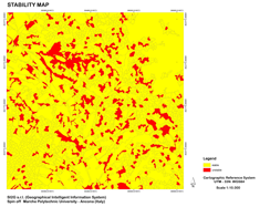
The output is a thematic map (Land Cover/Land Use) characterized by a good performance and a custom-designed legend. T-MAP's strong point is also a detailed accuracy assessment by means of stability maps and ad-hoc indexes that help the user to recognize stable regions from the instable ones which should be verified before being used. T-MAP modular structure and its GIS environment allow to enhance and widen its performance in terms landscape monitoring change over time and facilitate its use as a valid GIS decision support system.Segmentation
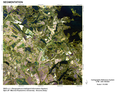
>> View the example of T-MAP's segmentation
Land Use map

>> View the example of T-MAP's LULC map
stability map